A2 Boundary Glacier Route - July 11, 2003

The Boundary Glacier Route on A2

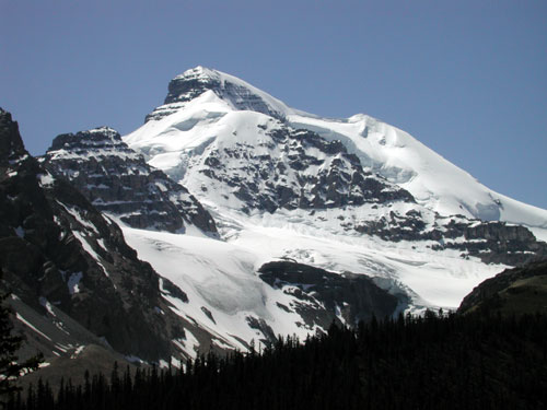
This route has been popular among mountain guides as it is slightly lower Than Mt. Athabasca and can sometimes be in condition when Athabasca is not. It also has some rock shortroping and rock climbing on the summit block. It has a number of obvious and hidden dangers that will be described below.

This is often one of the alternate choices for the summit day on day three of the Basic Snow and Ice Course (day five of Intro to Mountaineering). It is also a very common ascent during the Alpine Climbing course and Leadership Courses. There are at least three routes we commonly use to climb A2:

  • the Hilda Peak / A2 ice face,
  • the North Glacier of Athabasca to the Boundary / Athabasca col, or
  • the Boundary Glacier Route that is the subject of this essay.

If you are in the Icefields area and want something else to climb, consider one of the routes on A2. Between the three routes there is a tremendous range of difficulty.

The summit is 10,000 feet / 3000 meters above sea level which means altitude sickness is more rare than on the larger peaks nearby. Fit individuals will seldom suffer from affects of altitude during our climbs here. Headaches and feeling unduly tired are commonly the result of poor hydration, not sleeping well the previous night, not eating enough or simply poor fitness. Keeping hydrated and fed along with proper pacing and well spaced breaks are some ways to compensate for dehydration, altitude and lower fitness levels.

The quality of the rock on the upper mountain is poor, so rockfall and pulling on loose holds are possible scenarios. Climbing with appropriate caution makes this a manageable risk on this peak. Most of the rock work on this peak is easy shortroping (roped scrambling) until the final pitch below the summit.

Crevasse hazard is reasonably manageable on this route for much of the season. In recent years the crevasses have been posing quite a problem in late season (late August / September) especially lower on the glacier. In late season we often opt for the North Glacier route for this reason. Crevasse problems vary depending upon the time of year, the time of day and the quality of the snowpack. Good routefinding and proper ropework are still essential to safety. On this route crevasses are typically more of a danger than a slip or fall on snow so the way in which the rope is used will vary as the day progresses. In addition, depending upon the conditions, the way in which the rope will be used can vary from one day to the next even when travelling on exactly the same route. Judgment and situational awareness are key to proper ropework.

When snow conditions for crevasses are an issue we sometimes will ascend one route and descend another if conditions warrant a change of plan. It is common to come up the Boundary Glacier and go down the North Glacier where it is possible to get off the glacier readily midway.

The normal route traverses under seracs and icefall for a brief time. This means that large blocks of ice can suddenly break off and without warning fall down the mountain. Icefall went right across the normal route in 2003 when a large overhanging section of ice collapsed in the middle of the night. The equivalent to a large size 3 avalanche ran across a recent set of climbers tracks.

Avalanches can also happen here but are not especially likely. Summer avalanches here are more likely just after a snow storm, in early season or in the afternoon as the snow warms up and weakens. Avalanches are also more likely on a day following a warm night during which the snow did not freeze well at night. Best conditions follow a cold clear night which freezes things in place. It is best to get up very early so that the descent is made early in the day before the hazard level rises. You should still be willing to turn back if conditions are too warm or the snow is still moist early in the morning.

If conditions are poor on this route in the morning we sometimes consider Boundary peak instead. It is easier and even less objectively hazardous. Boundary Peak is easily accessed from the same approach and is a handy alternative route.

The photo below shows Mt. Athabasca in the center with A2 being the rock peak left of center. The steep snow / ice face directly below A2 is the Hilda Pesk / A2 ice face. The Boundary Glacier Route gains the glacier on the right hand edge.


[N Face Photo]

A Break at the Lake - 04:30 AM

After the first half hour of travel in the dark, the group pauses at Boundary Lake to adjust packs and clothing and make a short bathroom break. The group left the parking lot at Sunwapta Pass at around 04:00 AM.


[Pitch 2 Photo]
Sunrise - 05:30 AM


[Leading Pitch 5 Photo]
Icefall - 05:40 AM

This overhanging section of ice let loose a volley of blocks equivalent to a size 3 avalanche earlier in the season. This is no place to slow down or stop. Each cubic meter of ice weighs nearly a tonne and there were hundreds of tonnes of ice strewn across the lower glacier.


[Pitch 5 Photo]
Hilda Peak (A3) - 05:55 AM

This face between Hilda Peak and A2 makes a nice alpine ice climb. We sometimes use this as our ascent and descent route on Intermediate Ice, Intermediate Alpine and Leadership Courses. It requires ice anchors and protection and belayed climbing for a half dozen pitches or so depending upon the line chosen.


[Pitch 5 Photo]
Rope Up for the Glacier - 06:10 AM


[Pitch 6 Photo]
On the Boundary Glacier - 07:05 AM

The snow cover over the crevasses is good right now with not a lot of sags showing. The overnight freeze was not particularly good and the climbers are already starting to break through the crust into moist snow below. Once this crust breaks down later in the day the avalanche hazard will rise and travel will become more difficult. The crevasse risk will go up at the same time. Best not to waste time.


[Pitch 7 Photo]
A2 - The Upper Rocks - 07:25 AM

Once the groups traverses around the obvious crevasses blocking their path it will be fairly smooth sailing until below the final rocks. There is still a bergschrund to contend with that usually has a reasonably good bridge or a way around it. The group will head toward the small rock towers visible on the far right of the peak.


[Crux Pitch Photo]
Crevasses ! - 07:45 AM

Just about at the base of the towers the group gets a view of some gigantic slots.


[Crux Pitch Photo]
On the Rocks - 08:00 AM

After the short break for a snack and to switch to shortroping mode, the group carries on. Most of the remaining climbing will now be on rock.


[Lee on Pitch 7 Photo]
Narrow - 08:12 AM


[Lee Past Crux Photo]
Rigging an Anchor - 08:20 AM

The final summit block becomes steeper and more exposed. While still technically fairly straightforward, this is no longer shortroping terrain. Fixed pitons make for a rapid setup.


[Photo of Cyril on Summit]
Careful - 08:25 AM

Loose rock requires careful placement of hands and feet and attention to where the rope is running to avoid rockfall or a bad fall.


[Photo of Cyril on Summit]
Here we come - 08:40 AM

The rest of the group seconds the pitch, leaving the protection in place. On the way down, this pitch will be downclimbed and the protection will be clipped in again to protect the leader as he descends.


[Photo of Cyril on Summit]
Shorten the Rope Again - 08:45 AM


[Photo of Lee on Summit]
Shortrope to the Top - 08:48 AM


[Photo of Lee on Summit]
Summit of A2- 10,000' / 3000m - 08:50 AM

Time for a snack and some photos. With the soft snow only getting softer the group will not spend too much time up here today.


[Photo of top of N Face]
Back a Different Way - 10:04 AM

The group heads for the Athabasca / Boundary Col. Notice the old avalanche debris in the background just above the tracks. Avalanches have not yet started to run on this face today, but in a few hours it will be a totally different story.


[Photo of Lee on Summit]
Another Summit - Boundary Peak - 11:05 AM

With the group moving well it is decided to bag another peak. From here the group can descend without having to get back on a glacier.


[Photo of Lee on Summit]
A2 - 11:20 AM

The group can now begin to relax a little as the hazards of altitude, crevasses, slips and falls on snow and ice are over. Warm clothes come off, crampons and ice axes get stowed and the rope is stuffed into its bag.

With no changing snow conditions to worry about down below the group takes a longer lunch break and surveys the route from the morning. If you look carefully you can see the tracks from the morning.


[Photo of Lee on Summit]
Down the Scree - 11:50 AM


[Photo of Lee on Summit]
Glissade ! - 12:00 Noon


[Photo of top of N Face]
Not Far Now - 12:45 PM

After another extended break by a stream in a meadow the group makes off for the final leg of their journey. The weather is fine and the terrain is interesting and diverse.


[Photo of top of N Face]
Final Stream Crossing - 1:15 PM

With Snowdome and Mt. Kitchener in the background, they complete the final steam crossing. In ten minutes they will be back at the vehicles ready to head home.


[Photo of top of N Face]
Boots Off - 1:30 PM

This group made the return trip in about nine and a half hours which is good time considering that they had difficult trail breaking in the morning and summitted two peaks. Between eight and ten hours is standard for this route on A2 in normal conditions. If conditions were better it is possible to be a bit faster. Conversely when conditions are worse it has taken more than ten hours to climbA2.

It is essential on peaks of this type to get up very early, start early and try to finish early before deteriorating conditions make travel even slower and more dangerous. On days when things are not right, groups must be willing to turn back, change routes or sometimes change objectives entirely to climb a safer line or a safer mountain.

Stay Safe!


Home Page What is Rescue Dynamics ?
Summer Climbing Courses Animated Rescue Dynamics Logo Custom & Private Guide Services
Winter Climbing and Skiing Courses Mountain Weather Forecasts
First Aid and WEC Courses Photo Essays
Rescue Courses Outdoor Article of the Month
Custom Courses Current Climbing and Ski Conditions
Upcoming Course Dates What's New ? Course Application Forms


[Made with Macintosh Icon]
Further Information, Comments, Suggestions?
Cyril Shokoples

Rescue Dynamics
Edmonton, AB, Canada T6L 1K5

Copyright © 1997 Cyril Shokoples
All rights reserved. Terms & Conditions apply.
Last updated Monday, May 29, 2023