Mt. Athabasca AA Col Route - June 27, 2003

The AA Col Route on Mt. Athabasca

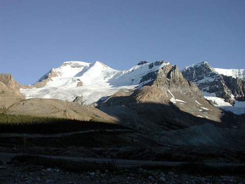
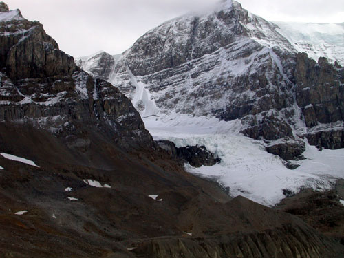
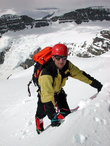
This route was becoming increasingly popular as it had fewer objective hazards than the North Glacier Route. It still has a number of obvious and hidden dangers that will be described below. This was often one of the first choices for the summit day on day three of the Basic Snow and Ice Course (day five of Intro to Mountaineering).

In 2023 the approach to the route has become increasingly hazardous, so the following description may not be valid any longer.

The summit is 11.452 feet / 3491 meters above sea level which means altitude sickness, although rare, is possible and has happened here. Quite often fit individuals will suffer from minor affects of altitude during our climbs. Headaches and feeling unduly tired are common complaints. Keeping hydrated and fed are two ways to combat this, along with proper pacing and well spaced breaks.

Crevasse hazard is more manageable on this route than the North Glacier for much of the season. It still varies depending upon the time of year, the time of day and the quality of the snowpack. Good routefinding and proper ropework are still essential to safety. On this route a slip or fall is more of a danger than crevasses so the way in which the rope is used will vary as the day progresses. In addition, depending upon the conditions, the way in which the rope will be used can vary from one day to the next even when travelling on exactly the same route. Judgment and situational awareness are key to proper ropework.

This route normally does not traverse under seracs or icefall (unless you are lost or get off route). Just to the side of the lower part of the route there is substantial icefall hazard that can be almost completely avoided when on the correct route.

Avalanches can also happen here especially on the steep slope above the flat lower portion of the "AA" Glacier. Avalanches here are more likely just after a snow storm, in early season or in the afternoon as the snow warms up and weakens. Avalanches are also more likely on a day following a warm night during which the snow did not freeze well at night. Best conditions follow a cold clear night which freezes things in place. It is still best to get up very early and start your climb in the dark so that the descent is made early in the day before the hazard level rises. You also have to be willing to turn back if conditions are too warm or the snow is still moist early in the morning.

During our guided ascents we take groups on this route when we feel the conditions are poor on the North Glacier Route but exceptable on this side of the mountain where the route is in shade until around 11:00 AM. Sometimes we will ascend one route and descend another if conditions warrant a change of plan.

If conditions are poor here in the morning we sometimes consider Boundary peak which is easier and even less objectively hazardous.

The photos in this essay were taken on the fifth wedding anniversary of Dave and Cheryl Devin. Dave and Cheryl were married on the summit five years ago by me (Cyril). On the wedding day Sandra was the videographer and she made the ascent again today.

All of the folks in these photos have summitted Mt. Athabasca more than once. This was Cheryl's third ascent; Dave had made multiple ascents including the North Face; Sandra had many ascents including this route, the North Glacier Route and the Silverhorn Face Route. This was my 75th ascent if my current count is correct! I have climbed the peak by six different routes in most conditions and during most months of the year at one time or another.

The lower portion of the AA glacier is shown in the center of the photo below. The route goes up the far left hand side of the glacier and passes the obvious icefall via easy rocks on the climber's left. The peak behind the glacier on the right is Mt. Andromeda. The name "AA Col" comes from the fact that the col or pass is between Mounts Athabasca and Andromeda.


[N Face Photo]

At the top of the Moraine - 04:50 AM

The group started up at 03:45 AM ! The route for the next half hour or so would not normally warrant a rope for a group of this experience level but recent snowy conditions potentially made the rocks above more slippery than normal so the group decided to put on the rope just in case things got tricky.


[Pitch 2 Photo]
The Icefall at Sunrise - 04:50 AM


[Leading Pitch 5 Photo]
Easy Scrambling on Lower Rocks - 05:25 AM


[Pitch 5 Photo]
Crampons on for the Glacier - 05:40 AM

After a cold night, temperatures are still cold on the shady side of the mountain. Travel from here will be roped up due to crevasse risk.


[Pitch 5 Photo]
Approaching the Big Slope - 06:30 AM

Risk of avalanches on this slope requires ongoing assessment of snow conditions. Groups have reached this slope and had to turn around due to unstable snow on many occasions over the years. You can spot numerous avalanches in this photo. They occurred during warm weather a few days ago.

The route often goes justly slightly left of centre to cross a large bergschrund which guards the upper slopes. The bergschrund is well covered by avalanche debris today. The track then goes into the centre of the slope and then switchbacks hard left on the lowest angle terrain possible. A sort of left leaning snow ramp can be seen in this photo that roughly outlines where the route goes. (It is not actually a ramp but appears like one in the photo.) The route gains a broad area called the "saddle" by going through one of several gullies. Groups will sometimes take the slope directly for practice on slightly steeper terrain.


[Pitch 6 Photo]
The Lower AA Glacier - 06:30 AM

Today the overnight freeze has the climbers usually barely penetrating the crust formed in the cold temperatures overnight. Once this crust breaks down later in the day the avalanche hazard will rise and travel will become more difficult. The crevasse risk will go up at the same time. Best not to waste time.


[Pitch 7 Photo]
Steep ! - 08:10AM

The snow conditions on the upper slope were extremely difficult, varying between a breakable crust and rock hard cramponing. Step kicking was an onerous task and time was lost in the process. The group had tired calf muscles climbing the 1300' / 400m slope to this point.


[Crux Pitch Photo]
The Saddle - 08:20 AM

After the steep climb it is time for a break for food and water. Still over 1000' / 300m to go to the summit.


[Crux Pitch Photo]
11,000 Feet / 3353 Meters - 08:50 AM

After the break, the group cracks the 11,000 foot elevation mark (3353m). Winter mitts and gloves were added to deal with the cooler temperatures at this altitude. The group is dressed for a winter day in late June!

The thinner air isn't slowing this group much. Many people find elevations above 10,000' / 3000m taxing unless their bodies are acclimatized. Some people find their hearts racing and must slow their pace or stop every few minutes to catch their breath. Other people hardly notice the elevation at all. Fitness does not necessarily imply immunity either. I have seen a trained marathon runner "hit the wall" at 10,000' while other less fit people on the rope seemed totally unaffected.


[Lee on Pitch 7 Photo]
The Silverhorn - 09:05 AM

From the top of the Silverhorn where this photo was taken to the summit of Mt. Athabasca proper usually takes between fifteen and twenty minutes depending upon conditions. This photo is taken looking toward Mt. Castleguard.


[Lee Past Crux Photo]
SUMMIT ! 11,452 feet / 3491 meters - 09:35 AM

The final step onto the very narrow summit can be a tricky one. On the summit there is usually just enough time for some photos and a snack but not for too long as the lower slopes are already beginning to get warm. Today the group will snap some photos and immediately depart to eat lunch a bit lower down between the two summits.


[Photo of Cyril on Summit]
Nigel Peak from the Top - 9:40 AM

The snowy peak on the right center side of the photo is a big 10,000 foot peak. It has a scramble route to the summit which has little to recommend it except the views of the Icefields Peaks.


[Photo of Cyril on Summit]
Happy Anniversary ! - 10:05 AM

On this spot just between the two summits Dave and Cheryl were married five years ago. The warm sun makes for great memories and awesome ambience. After a casual lunch we realize it will soon be time to go.


[Photo of Cyril on Summit]
Snacks Before We Go - 10:10 AM


[Photo of Lee on Summit]
Descending the Silverhorn - 10:40 AM

The snow at 11,000' is still hard enough to require crampons and sometimes the points are barely penetrating the icy crust. Later in the season when the snow melts there is actually a path in the scree in the upper part of the Silverhorn. There is little sign of that today.

The group travels with a shortened rope distance between them as a slip and fall is a possible hazard. It is easier to check a slip with less rope between climbers. Lower down once the group gets onto the crevassed portion of the glacier the rope between climbers will be lengthened for normal glacier travel.


[Photo of Lee on Summit]
Back Down the Steeps - 11:10 AM

The sun is now beginning to hit this critical slope on the descent. This is the steepest slope on the route with the most avalanche potential. The crust is still holding everything together for now but direct solar radiation and rising temperatures will change that in short order. No time to dawdle. The hidden bergschrund can be seen by the trained eye in this photo as well as evidence of recent sluffing / avalanches a few days ago.


[Photo of top of N Face]
On the Lower Glacier - 11:45 AM

Crampons off for the softening snow and rope being stretched out as we head across the hidden crevasses of the lower glacier.


[Photo of Lee on Summit]
Posers - 12:05 Noon

With Andromeda and the famous climbing route the "Andromeda Strain" as a backdrop, the group strikes a pose before stepping off the snow and the glacier.


[Photo of Lee on Summit]
Off the Glacier and Off the Rope - 12:10 Noon

The group can now begin to relax a little as the hazards of altitude, crevasses, slips and falls on snow and ice are behind them. Winter clothes come off, crampons and ice axes get stowed and the rope is stuffed into its bag. With no changing snow conditions to worry about down below the group takes a longer break and relaxes and ponders the quiet solitude.

Just another 1500 feet or more of elevation to lose to get back to the vehicles. Although the group had the rope on for the next section on the way up, conditions were better than anticipated so this experienced crew will not require the additional security a rope might provide for a less experienced climber. There are still plenty of opportunities to get injured on loose ground on the cliffs and moraines below, so they can't quite relax completely.


[Photo of Lee on Summit]
Icefall Backdrop - 12:45 PM


[Photo of Lee on Summit]
Lower Moraine Trail - 12:55 PM


[Photo of top of N Face]
Not Far Now - 1:00 PM

With Mt. Wilcox and Tangle Peak egging the group on, they complete the final walk down the moraines. In half an hour they will be back at the vehicles ready to travel to Jasper for a celebratory supper in a fine restaurant.

This group made the return trip in about nine and a half hours which is near normal. Between eight and ten hours is standard for this route in normal conditions. If conditions were better it is possible to be quite a bit faster. Conversely when conditions are worse it has taken more than twelve hours to climb Mt. Athabasca. A less experienced group may not have dealt as well with the altitude and conditions and the trip could have taken longer.

It is essential on peaks of this type to get up very early, start early and try to finish early before deteriorating conditions make travel even slower and more dangerous. On some ascents we start as early as 03:00 in the morning. On days when things are not right, groups must be willing to turn back, change routes or sometimes change objectives entirely to climb a safer line or a safer mountain.

Stay Safe!


Home Page What is Rescue Dynamics ?
Summer Climbing Courses Animated Rescue Dynamics Logo Custom & Private Guide Services
Winter Climbing and Skiing Courses Mountain Weather Forecasts
First Aid and WEC Courses Photo Essays
Rescue Courses Outdoor Article of the Month
Custom Courses Current Climbing and Ski Conditions
Upcoming Course Dates What's New ? Course Application Forms


[Made with Macintosh Icon]
Further Information, Comments, Suggestions?
Cyril Shokoples

Rescue Dynamics
Edmonton, AB, Canada T6L 1K5

Copyright © 1997 Cyril Shokoples
All rights reserved. Terms & Conditions apply.
Last updated Monday, May 29, 2023