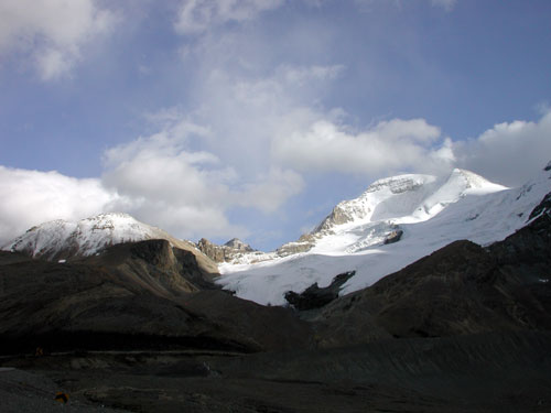
This route is one of our standby routes. We use it when for one reason or another we choose not to climb one of the larger and more objectively hazardous neighbouring peaks. It has far fewer objective hazards than the North Glacier Route on Athabasca for example and can be climbed in more marginal conditions. It also requires less time to complete. It is a superb viewpoint in its own right and is worth doing at least once as a shorter "photographer's day". It still has a number of obvious and hidden dangers that will be described below. This is one of the backup choices for the summit day on day three of the Basic Snow and Ice Course (day five of Intro to Mountaineering) or day two of the Alpine Climbing Course. The summit is less than 10,000 feet / 3000 meters above sea level which means altitude sickness is more rare than on the larger peaks nearby. Fit individuals will seldom suffer from affects of altitude during our climbs here. Headaches and feeling unduly tired are commonly the result of poor hydration, not sleeping well the previous night, not eating enough or simply poor fitness. Keeping hydrated and fed along with proper pacing and well spaced breaks are some ways to compensate for dehydration, altitude and lower fitness levels. Crevasse hazard is more manageable on this route than the North Glacier for much of the season. It still varies depending upon the time of year, the time of day and the quality of the snowpack. Good routefinding and proper ropework are still essential to safety. On this route a slip or fall and hidden crevasses are potential hazards but are less of a problem than on the other routes we do in the area, so the way in which the rope is used will vary as the day progresses. In addition, depending upon the conditions, the way in which the rope will be used can vary from one day to the next even when travelling on exactly the same route. Judgment and situational awareness are key to proper ropework. This route does not traverse under seracs or icefall (unless you are lost or get off route). Avalanches can also happen here but are far less likely. Summer avalanches here are more likely just after a snow storm, in early season or in the afternoon as the snow warms up and weakens. Avalanches are also more likely on a day following a warm night during which the snow did not freeze well at night. Best conditions follow a cold clear night which freezes things in place. It is still best to get up reasonably early so that the descent is made early in the day before the hazard level rises. You should still be willing to turn back if conditions are too warm or the snow is still moist early in the morning. During our guided ascents we take groups on this route when we feel the conditions are poor on the other surrounding peaks but exceptable on this shorter less complicated route. This route is also used when fitness or other physical conditions are factors. Often we will ascend one route and descend another to make a nice round trip. If conditions are poor here in the morning it often means that nothing in the area will be fit to climb and the day may be cancelled. Pouring rain in the morning would be one example of a day that may not be suitable even for Boundary Peak. Occasional showers or snow flurries may even be acceptable depending upon the time of year and forecast. The photo below shows Boundary Peak on the left and Athabasca on the right with "A2" just peaking out over the col in the middle. The route ascends the lefthand side of the glacier in the center of the photo below. The route climbs up a tongue of ice that steepens up to where crampons are usually required before mellowing out in the middle section. The route ascends to the col or pass between the two peaks then follows a rock and scree ridge to the summit.
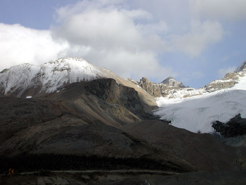
The North Glacier Route on Boundary Peak
![[N Face Photo]](Kitchener082102.jpg)
![[Pitch 2 Photo]](Wilcox082102.jpg)
![[Leading Pitch 5 Photo]](Athabasca082102.jpg)
![[Pitch 5 Photo]](NorthGlac082102.jpg)
![[Pitch 5 Photo]](summit082102.jpg)
![[Pitch 6 Photo]](summit090202.jpg)
![[Pitch 7 Photo]](A2bizarre082102.jpg)
![[Crux Pitch Photo]](Nglacapproach082102.jpg)
![[Crux Pitch Photo]](Nglacall082102.jpg)